![](/images/other/stat-length.png)
![Trail Walking La Livinière - 34-La Livinière : Les Fours à Chaux (Hérault)-16/02/2014 - Photo](https://media.geolcdn.com/t/1900/400/ext.pjpeg?maxdim=2&url=https%3A%2F%2Fstatic1.geolcdn.com%2Fsiteimages%2Fupload%2Ffiles%2F1553511878bg_sport_marche.png)
34-La Livinière : Les Fours à Chaux (Hérault)-16/02/2014
Jovila
User
![Length](/images/other/stat-length.png)
![Max alt](https://static1.geolcdn.com/siteimages/upload/files/1508320355ic_sort_altitude_max_24dp.png)
![Uphill gradient](https://static1.geolcdn.com/siteimages/upload/files/1508320355ic_sort_den_pos_24dp.png)
![Km-Effort](/images/other/stat-length.png)
![Min alt](https://static1.geolcdn.com/siteimages/upload/files/1508320355ic_sort_altitude_min_24dp.png)
![Downhill gradient](https://static1.geolcdn.com/siteimages/upload/files/1508320355ic_sort_den_neg_24dp.png)
![Boucle](https://static1.geolcdn.com/siteimages/upload/files/16400158638029165_repeat_loop_refresh_sync_direction_icon.png)
![Walking](https://static1.geolcdn.com/sitytour/trail-icons/101.png)
2h26
Difficulty : Easy
![Scan this QR Code to open this trail in the SityTrail application](https://capi.geolives.com/qq0zvz2zws4bq2lad0pu/sitytour/trails/250527/qr.png?size=200)
FREE GPS app for hiking
About
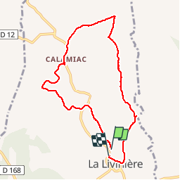
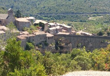
Trail Walking of 8.8 km to be discovered at Occitania, Hérault, La Livinière. This trail is proposed by Jovila.
Description
Départ : parking à gauche sortie du village sur D 12 E.
Reprendre la D12 en montant puis prendre la 1ere rue à droite et continuer tout droit sur la gauche.
- Suivre le Balisage Jaune (pas très net à certains endroits).
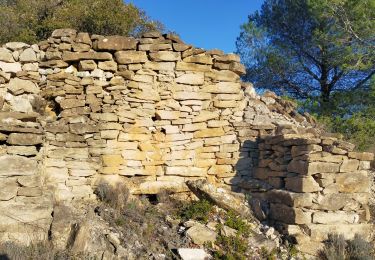
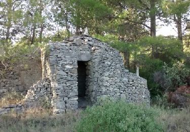
-Après le montée faire un allée retour à gauche (panneau capitelle (dans les feuillages à l'angle des 2 chemins)50 m plus loin encore à gauche petit panneau et admirer une magnifique capitelle de 3 pièces.
-Revenez sur vos pas.
- Et suivre toujours le balisage jaune.
- Plus loin sur le retour 2 fours à chaux dont un en parfait état.
Bonne Ballade
Positioning
Comments
Trails nearby
![Trail Cycle Azille - ferrals le bois minerve - Photo](https://media.geolcdn.com/t/375/260/ext.jpg?maxdim=2&url=https%3A%2F%2Fservices.sitytrail.com%2FGeolivesWS%2FDownloadMedia.ashx%3FTrailID%3D610268%26Media%3Dfix__20160807132114.jpg)
![Cycle Cycle](https://static1.geolcdn.com/sitytour/trail-icons/200.png)
Cycle
![](/images/other/stat-length.png)
![](https://static1.geolcdn.com/siteimages/upload/files/16400158638029165_repeat_loop_refresh_sync_direction_icon.png)
![Trail Cycle Azille - trois col en minervois - Photo](https://media.geolcdn.com/t/375/260/ext.jpg?maxdim=2&url=https%3A%2F%2Fstatic1.geolcdn.com%2Fsiteimages%2Fupload%2Ffiles%2F1524743154velo.jpg)
![Cycle Cycle](https://static1.geolcdn.com/sitytour/trail-icons/200.png)
Cycle
![](/images/other/stat-length.png)
![](https://static1.geolcdn.com/siteimages/upload/files/16400158638029165_repeat_loop_refresh_sync_direction_icon.png)
![Trail Walking Félines-Minervois - 34 - CAMPLONG - HAUTEURS DU VENTAJOU 13.5 Km - 04h18 - D 558 m - Photo](https://media.geolcdn.com/t/375/260/ext.jpg?maxdim=2&url=https%3A%2F%2Fstatic1.geolcdn.com%2Fsiteimages%2Fupload%2Ffiles%2F1553511878bg_sport_marche.png)
![Walking Walking](https://static1.geolcdn.com/sitytour/trail-icons/101.png)
Walking
![](/images/other/stat-length.png)
![](https://static1.geolcdn.com/siteimages/upload/files/16400158638029165_repeat_loop_refresh_sync_direction_icon.png)
![Trail Walking Rieux-Minervois - 2023 09 14 CHEMIN du PIÉMONT PYRÉNÉEN - 7ème étapes : RIEUX-Minervois - MALVES-en-Minervois - Écluse de L’Évêque - CARCASSONNE - Photo](https://media.geolcdn.com/t/375/260/f0fb17d9-5eec-4530-a64f-e1830613a496.jpg&format=jpg&maxdim=2)
![Walking Walking](https://static1.geolcdn.com/sitytour/trail-icons/101.png)
Walking
![](/images/other/stat-length.png)
![](https://static1.geolcdn.com/siteimages/upload/files/16400158638029165_repeat_loop_refresh_sync_direction_icon.png)
![Trail On foot Félines-Minervois - Le sentier des Marbrières - Photo](https://media.geolcdn.com/t/375/260/4f5f3bcd-ba04-4c89-b29f-747346a9300b.jpeg&format=jpg&maxdim=2)
![On foot On foot](https://static1.geolcdn.com/sitytour/trail-icons/100.png)
On foot
![](/images/other/stat-length.png)
![](https://static1.geolcdn.com/siteimages/upload/files/16400158638029165_repeat_loop_refresh_sync_direction_icon.png)
![Trail Walking La Livinière - LA LIVINIERE: Les fours à chaux. - Photo](https://media.geolcdn.com/t/375/260/1a1cfd60-0d27-4261-950b-2e80121f0deb.jpeg&format=jpg&maxdim=2)
![Walking Walking](https://static1.geolcdn.com/sitytour/trail-icons/101.png)
Walking
![](/images/other/stat-length.png)
![](https://static1.geolcdn.com/siteimages/upload/files/16400158638029165_repeat_loop_refresh_sync_direction_icon.png)
![Trail Walking Siran - Centeilles - Photo](https://media.geolcdn.com/t/375/260/ext.jpg?maxdim=2&url=https%3A%2F%2Fservices.sitytrail.com%2FGeolivesWS%2FDownloadMedia.ashx%3FTrailID%3D493850%26Media%3Dfix__20151114151824.jpg)
![Walking Walking](https://static1.geolcdn.com/sitytour/trail-icons/101.png)
![Trail Walking Félines-Minervois - l'abearadou - Photo](https://media.geolcdn.com/t/375/260/ext.jpg?maxdim=2&url=https%3A%2F%2Fservices.sitytrail.com%2FGeolivesWS%2FDownloadMedia.ashx%3FTrailID%3D263700%26Media%3Dfix__20140406102308.jpg)
![Walking Walking](https://static1.geolcdn.com/sitytour/trail-icons/101.png)
Walking
![](/images/other/stat-length.png)
![](https://static1.geolcdn.com/siteimages/upload/files/16400158638029165_repeat_loop_refresh_sync_direction_icon.png)
![Trail Walking Félines-Minervois - camplong - Photo](https://media.geolcdn.com/t/375/260/e7819e8a-0ca4-486b-89a2-5f0cb8a684ac.jpg&format=jpg&maxdim=2)
![Walking Walking](https://static1.geolcdn.com/sitytour/trail-icons/101.png)
Walking
![](/images/other/stat-length.png)
![](https://static1.geolcdn.com/siteimages/upload/files/16400158638029165_repeat_loop_refresh_sync_direction_icon.png)